Jeju Olle Trail Course 2 is a coastal walk on Jeju’s east side. It starts at Gwangchigi Beach in Seongsan and ends at Onpyeong Port. Along the way it climbs one real hill, Daesusan-bong, then drops back to the shoreline and follows it to the harbor. Beach, peak, coast, port. That’s the route.
Why spend a day of a short trip on it? You get two sides of Jeju in one walk. You set off on the black lava rock beside Seongsan, earn a summit view with your own legs, and finish in a fishing harbor where the trail just stops at the water. On Google Maps the course holds 4.6 stars from 312 reviews. The only warning in those reviews is the uphill, and legs that are still sore the next morning.
Most people who walk it are glad they did. Here’s what helps it go well.
🗺️ Jeju Olle Trail Course 2 at a Glance
Jeju Olle Trail Course 2 runs from Gwangchigi Beach (광치기해변) to Onpyeong Port (온평포구), both in Seongsan-eup on the east coast of Jeju. Below is the basic information from the Google Maps listing. Anything not in this table I’ve left out on purpose, so nothing here is a guess.
| Start | Gwangchigi Beach, Seongsan |
| High point | Daesusan-bong (대수산봉) |
| Finish | Onpyeong Port |
| Listed address | Goseong-ri, Seongsan-eup, Seogwipo-si, Jeju-do |
| Hours | Open 24 hours, Monday to Sunday |
| Reservation | None. It’s a walking route, not a venue |
| Phone on listing | 064-762-2190 |
| Google rating | 4.6 (312 reviews) |
“Open 24 hours” means nobody locks a gate. It doesn’t mean you should walk it in the dark. The climb and the rocky coastal stretches both need daylight, so plan to finish well before sunset.
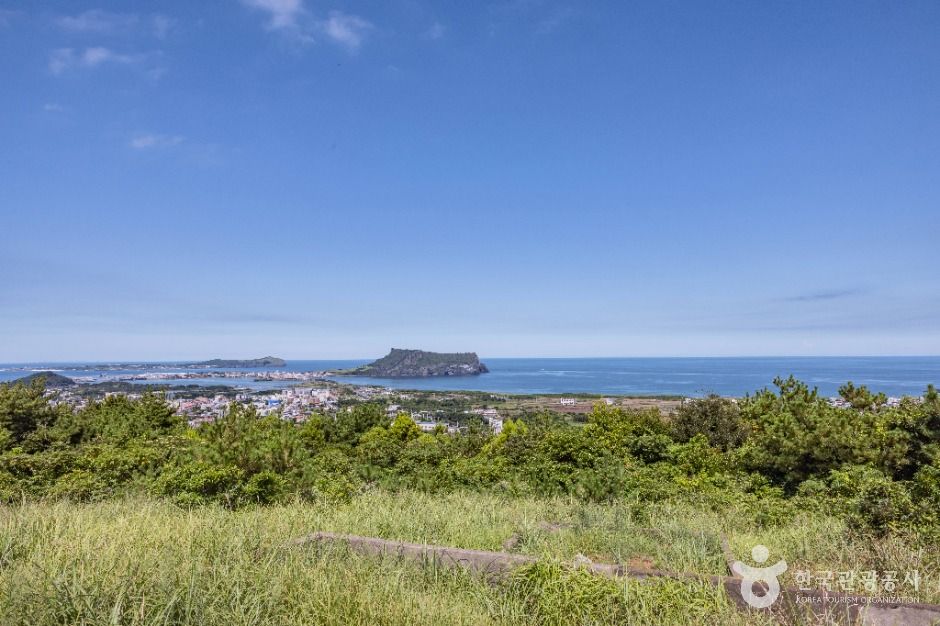
⛰️ Why Course 2 Earns a Day
Olle Course 2 packs in more variety than its short description suggests. A lot of Olle routes stay flat and hug the shore the whole way, which is pleasant but can blur together after a couple of hours. Course 2 breaks that up with a climb in the middle.
The climb changes how the second half feels. By the time you’re back down on the coast, you’ve already seen the whole stretch from above, so you know roughly where you’re heading. Walking toward a harbor you spotted an hour earlier from the peak is a good feeling.
It also suits photographers. Reviewers keep coming back to the pictures and the viewpoints, and that matches the route: an open beach, a summit view, and a harbor at the end. You’ll get good light at least once whatever time you start.
Short version: if you only have one day to walk on Jeju’s east side and you’re fine with one honest uphill, this is a strong pick.
🥾 The Route in Three Parts
The Course 2 route breaks into three parts that each feel different. Here’s what to expect in each one, in walking order.
Part 1: Gwangchigi Beach
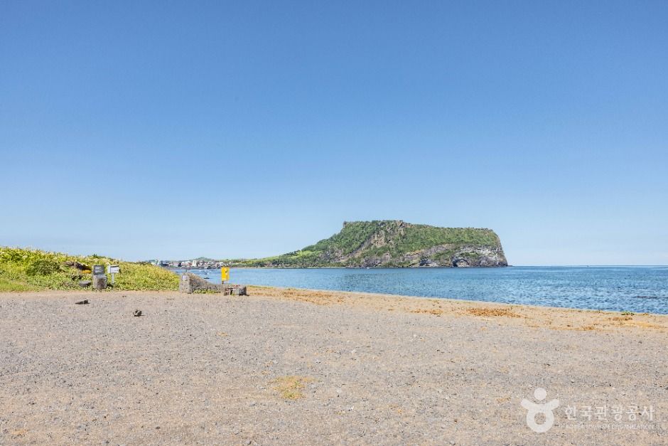
Gwangchigi Beach is the starting line, and it’s worth lingering for ten minutes before you set off. The shore is dark volcanic rock, and Seongsan Ilchulbong sits right behind you. A lot of people take their best photo of the whole day here, before they’ve walked a single step.
The beach is also where Course 1 finishes. If you see walkers who look tired rather than fresh, they’re probably ending their day while you’re starting yours. Find the start marker and the stamp box before you leave the beach. If you’re carrying an Olle passport, stamp it here first.
Part 2: The Climb Up Daesusan-bong
Daesusan-bong is the peak of Course 2, literally and in effect. The trail heads inland and goes up, and this is the stretch one reviewer meant by “be ready” and legs aching the next day. It’s a hill, not a mountain expedition. Still, it’s steeper than the coastal walking around it.
Take it slowly. Nobody’s timing you, and stopping halfway to look back toward Seongsan is half the reason to come up. At the top you get the wide view that makes the rest of the route make sense: coast on one side, farmland and low hills on the other.
Going down is where tired legs complain most. If your knees don’t like descents, slow down here more than you did on the way up.
Part 3: Back to the Coast and Onpyeong Port
After Daesusan-bong, Course 2 returns to the shoreline and follows it to Onpyeong Port. This last part is the easiest walking of the day, and it’s where you’ll notice the sea most: the wind, the black rocks, the boats tied up as you get close to the harbor.
The route ends at the port, at the edge of the water. Onpyeong Port is also where Course 3 begins, so you may see fresh walkers setting out as you finish. Stamp your passport at the end box before you look for a ride. It’s easy to forget once you’re thinking about food.
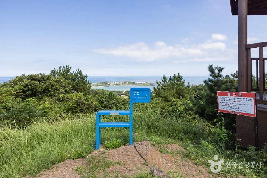
🎀 Following the Markers Without Getting Lost
Jeju Olle routes are marked the same way across the island, and Course 2 is no different. Once you know the system, you’ll rarely need your phone.
- Ribbons: blue and orange ribbons tied together on branches, fences and poles. Seeing them means you’re on the route.
- Arrows: painted on walls, rocks and the road. Blue arrows point in the official walking direction (toward Onpyeong). Orange arrows point the other way, for people walking it in reverse.
- Ganse markers: small horse-shaped posts. The head points the way forward.
- Stamp boxes: at the start and the finish, and usually one somewhere in between. They double as reassurance that you haven’t wandered off.
One habit helps a lot. If you’ve walked a few minutes without seeing a ribbon or arrow, stop and go back to the last one you saw. Junctions in farm villages are where people go wrong, usually because they kept talking and walked past a turn.
🚌 Getting to Gwangchigi and Back from Onpyeong
Gwangchigi Beach and Onpyeong Port are both in Seongsan-eup on Jeju’s east coast, so the logistics of Course 2 are simple: one way out, one way back. The thing to sort out is the return, because the walk is one-way and doesn’t loop.
I’m not giving bus numbers or travel times here. Jeju bus routes change, and a wrong number on a lonely coastal road is worse than no number. Use the map apps instead. They’re accurate on Jeju.
- Naver Map or Kakao Map: search the start in Korean (광치기해변) and the finish (온평포구) for the most reliable results. Both apps show live bus arrivals.
- Kakao T: for a taxi back from Onpyeong Port if you’re tired, or if the next bus is a long wait. Set it up on your phone before your trip.
- Check the return before you start. Look up the last bus from Onpyeong in the morning while you still have time to change plans. That five-minute check is the most useful thing on this list.
If you’re staying in Jeju City and driving or busing out along the north-east coast, you’ll pass Hamdeok on the way. Our guide to Hamdeok Beach and its quieter west side works well as a rest stop the day before or after.
🎒 What to Wear and Carry
For Olle Course 2, pack for both a hill and an exposed coast. Each needs its own gear, and the east coast gives you very little shelter.
- Shoes with grip. Walking shoes or trail runners. Sandals are miserable on the climb and worse on wet lava rock.
- Water, more than you think. Stretches of the route pass through farmland with no shops. Fill up before you leave Gwangchigi.
- Snacks. Eat something at the top of Daesusan-bong. The coastal part is easier when you’re not running on empty.
- A windproof layer. Jeju’s coast is windy, and the shore can feel much colder than the forecast suggests.
- Sun protection. Hat and sunscreen. There’s not much shade on the beach or along the shoreline.
- A charged phone and some cash. The phone is for the map and Kakao T. Cash covers a small village shop that might not take your card.
Pack light. You’ll carry that bag up a hill and along the coast for most of a day, and every extra thing in it adds up by the time you reach the port.
🕗 When to Walk It
The best time to start Olle Course 2 is the morning. You do the climb while you’re fresh and the air is cooler, and you reach Onpyeong Port with plenty of light left to get home.
By season
- Spring and autumn: the comfortable months for a full walk. If your dates are flexible, aim for these.
- Summer: the climb gets hard in the heat and the coast has little shade. Start as early as you can and carry extra water.
- Winter: clear days can be beautiful, but the wind off the sea bites. Wear layers and check the forecast for strong wind.
On rainy days
Wet lava rock is slippery, and so is a muddy path down a hill. If it’s pouring, move Course 2 to another day. For a gentler option on a grey day, Bijarim Forest is two easy hours among very old trees, also on the east side and far kinder underfoot.
🧭 Fitting Course 2 Into Your Trip
Olle Course 2 is easiest to plan if you’re staying on the east side, around Seongsan. A morning start at Gwangchigi Beach doesn’t involve a long drive first, and you can be back at your room soon after you finish.
Courses link into each other. Course 1 ends where Course 2 begins, and Course 3 starts where Course 2 ends. Walkers with time and strong legs sometimes do them back to back over several days. For most visitors on a short trip, one course is enough, and Course 2 is a good one to pick.
If you’re deciding between east and south, the two make a good contrast. Course 2 gives you a hill and an open coast. The south-coast route in our guide to Olle Course 7 and Seogwipo’s cliffs is about sea cliffs and cafe stops. Plenty of people do one of each on a longer stay.
For the latest route notes, closures and the official course map, the island’s tourism site is worth a check before you go: visitjeju.net.
❓ Short Answers
Where does Jeju Olle Trail Course 2 start and end?
Jeju Olle Trail Course 2 starts at Gwangchigi Beach in Seongsan and ends at Onpyeong Port. In between it climbs Daesusan-bong, then comes back down to the coast and follows the shoreline to the harbor. Both ends are in Seongsan-eup on Jeju’s east coast.
Is Course 2 hard?
Course 2 is moderate, with one real climb up Daesusan-bong. The coastal parts are easy walking. Reviewers say the uphill is the tough bit and their legs were sore the next day, but they still thought it was worth it. Reasonably fit walkers should be fine at their own pace.
Do I need to book or pay to walk it?
No booking is needed for Olle Course 2. It’s a walking route through public beach, hill and village paths, listed as open 24 hours every day. Just turn up at Gwangchigi Beach and follow the ribbons. An Olle passport for collecting stamps is optional.
How do I get back from Onpyeong Port?
From Onpyeong Port, take a local bus or call a taxi through Kakao T. Check the bus times in Naver Map or Kakao Map before you start walking, because the route is one-way and ends at a small harbor. Searching 온평포구 in Korean gives the most accurate results.
Can I walk Course 2 in the reverse direction?
Yes, you can walk Course 2 from Onpyeong Port to Gwangchigi Beach. Follow the orange arrows, which mark the reverse direction. The plus is that you finish facing Seongsan Ilchulbong. The minus is that fewer people go this way, so you’ll be reading the markers more carefully.
📝 Summary
- Jeju Olle Trail Course 2 goes Gwangchigi Beach → Daesusan-bong → coast → Onpyeong Port, all in Seongsan-eup.
- Google rating 4.6 from 312 reviews. Listed open 24 hours, but walk it in daylight.
- One real climb up Daesusan-bong. Expect sore legs, and take the descent slowly.
- Follow the blue and orange ribbons, blue arrows and horse-shaped ganse markers. Stamp at the start and finish.
- No booking. Check the return bus from Onpyeong in Naver Map or Kakao Map before you start, and keep Kakao T ready.
- Wear grippy shoes, and bring plenty of water, a windproof layer and sun protection. Start in the morning, and skip it in heavy rain.